
ALL-IN-ONE DESIGN
The device has built-in Bluetooth, radio, WIFI, storage, positioning, inertial navigation, and antenna modules. It can switch between base station mode and rover mode for automatic switching between the mobile and base station.
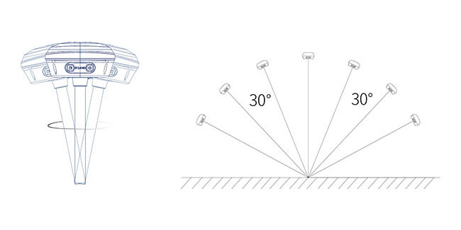
TILT COMPENSATION FOR HARD-TO-REACH MEASUREMENTS
The NebulasIV GNSS SoC integrates RF, baseband, and high-precision algorithms. It can track 40+ satellites for accurate positioning in complex environments. The built-in IMU module doesn't require calibration and achieves a 5cm tilt measurement accuracy (≤30°) with simple initialization.

One-Step setting via Website
BASE\ROVER mode, NTRIP mode, UHF working mode and other settings are completed in one step, tailored for precision agriculture.
ALL OF PARAMETERS
Signal Tracking:
BDS: B1I/B2I/B3I/ B1C/B2a/B2b
GPS: L1C/A/L1C/L2C/L2P(Y)/L5
GLONASS: G1/G2/G3
Galileo: E1/E5a/E5b/E6
QZSS: L1C/A/L1C/L2C/L5
NavIC: L5
SBAS: L1C/A
Cold Start Time: <12s
Initialization Time: <5s (typical)
RTK Initialization Reliability: >99.9%
Reacquisition Time: <1s
single point positioning:
Horizontal: 1.5m
Vertical: 2.5m
RTK Accuracy:
8mm+1ppm(RMS)
15mm+1ppm(RMS)
Static Accuracy:
2.5mm+1ppm(RMS)
5mm+1ppm(RMS)
speed accuracy:0.03m/s
Differential Data: RTCM3.X
Positioning Data: NMEA-0183
Static Data: Binary
Power Consumption:
Rover: ≤2.0W
Base Station: ≤2.2W
Battery Life:
Rover: ≥20h
Base Station: ≥15h
Radio Frequency: 410-470MHz
Input Voltage: 9-36V DC
Battery Capacity: 10000mAh
Radio Power: 0.5W/1.5W
Storage Capacity: 32GB
Data Refresh Rate: Default 1Hz, up to 20Hz
Interface Types:
Type-C, SIM card slot, TNC connector
Bluetooth:
BT4.1, backward compatible with BT2.x,
supports Windows/Android/iOS systems
WiFi: IEEE 802.11 a/b/g/n
Tilt Angle: 0-60°
Tilt Accuracy: 2.5cm (within 30°)